The concept
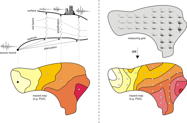
In the event of an earthquake, it is well known that the local site response due to strong ground motion may significantly vary in different locations of an urban area, according to local geological and geophysical conditions. Therefore, the traditional seismic zonation on a regional level (adopted in Seismic Codes), may be inadequate for a site-specific seismic hazard assessment and hence for a reliable estimation of the seismic risk on the local level. This deficiency led to the development of microzonation studies for medium to large cities, by estimating the amplified response of soil layers under earthquake excitation and thus the variation of strong motion characteristics on the ground surface. This estimation usually requires the application of numerical methods using borehole data (yet expensive and not easily applicable in highly populated urban areas), shear wave velocities, standard penetration test values, or even micro tremor measurements, finally resulting to a so called microzonation hazard map (left picture). However, it should be noted that the accuracy and the reliability of the above implicit procedures for estimating strong motion characteristics on the ground level, should be compromised with the reliability of the primary bedrock information, which depends not only on the seismological features (epicenter distance, depth etc.) of the respective event, but also on the applied attenuation relationships. It is hence obvious that the density and quality of the original open field measurements play a predominant role in reducing uncertainties in microzonation studies and generally in seismic hazard assessment procedures.
Since the ultimate goal of a microzonation study is to estimate the variation of strong motion characteristics on the ground level, it would have been theoretically ideal for the researcher to have access to an “infinitely” dense database of actual strong motion data for the region under consideration, in order to directly derive an explicit, effectively continuous distribution of strong motion characteristics on the respective region map. This advantage would not only greatly improve the reliability of seismic risk estimation in the considered urban area (with all implied economic and social benefits), but would also lead to further validation and optimization of existing analytical microzonation methods for future studies. Nevertheless, the application cost of this venture is prohibitive, mainly considering the high cost of specialized commercial instruments, but also the installation, maintenance and surveillance expenses. Consequently, applications of dense accelerometer networks on a local scale are sparsely implemented worldwide.
Since the ultimate goal of a microzonation study is to estimate the variation of strong motion characteristics on the ground level, it would have been theoretically ideal for the researcher to have access to an “infinitely” dense database of actual strong motion data for the region under consideration, in order to directly derive an explicit, effectively continuous distribution of strong motion characteristics on the respective region map. This advantage would not only greatly improve the reliability of seismic risk estimation in the considered urban area (with all implied economic and social benefits), but would also lead to further validation and optimization of existing analytical microzonation methods for future studies. Nevertheless, the application cost of this venture is prohibitive, mainly considering the high cost of specialized commercial instruments, but also the installation, maintenance and surveillance expenses. Consequently, applications of dense accelerometer networks on a local scale are sparsely implemented worldwide.
The key objective of the this research project is to develop an easily applicable and, most importantly, low-cost methodology for instrumenting urban areas (e.g. medium to large cities) on a adequately dense grid, in order to effectively capture actual strong motion data during moderate to strong seismic events (right picture). This will be realized by installing a dense network of in-house designed and manufactured, autonomous acceleration logging units, using the newest micro-electro-mechanical (MEMS) sensor technology. The recorded data will be later georeferenced and postprocessed using GIS software, in order to explicitly produce detailed hazard maps of the considered area. The whole procedure will require minimum maintenance and human intervention, focused only in the installation of logging units and the collection of strong motion data.

